An open source project to map one of the world's biggest slums
Siena AnstisWebsite
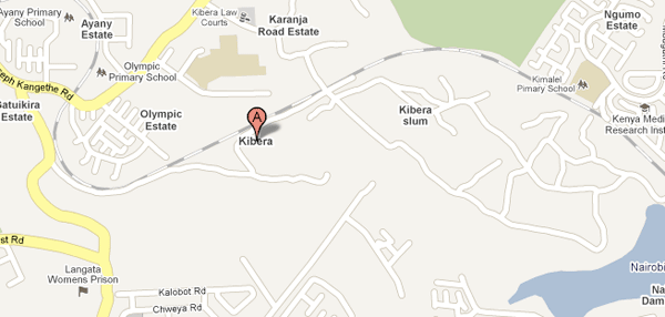
Google Map's incomplete data for Kibera, among the world's largest slums. An open source mapping project aims to provide a clearer picture.
Kibera, one of the world’s biggest slums, is a “glaring omission” on Google Maps, says Erica Hagen, member of the Map Kibera team. Indeed, Kibera remains a blank spot in relatively well-mapped and densely populated Nairobi, the economic hub of East Africa.
When I first heard of this project, my first thought was of the potential harm that mapping this area could do. Would the government highjack the data, mapping and labeling households by ethnicity? Of course, all technology has pitfalls. Remember the use of cell phones during the Kenyan election crisis to spread hate? It would serve Map Kibera well to monitor how the government and local political groups use this new information and for what means.
Regardless, mapping Kibera does have some expected benefits. As Hagen points out, community groups are willing to participate because they think having a geographical marker might make service claims to the government easier. There would be a visual representation of where schools, clinics and water delivery services, for example, are missing.
In a community saturated with development organizations, mapping might also better situate who is working where and potentially help avoid overlaps between groups. For Westerners, it is a practical matter of being able to navigate the complex community they do not belong to, but so desperately want to volunteer in.
Google Maps brings us visual representations of the nooks and crannies of the world we would probably never have time or money to visit. This points to another advantage of mapping Kibera. Hagen is working with a group of youth who produce short clips of their community and upload to YouTube. By linking these clips to different areas of Kibera on a map there is the potential to better educate and situate Kibera for the aid-giving Westerners who see the region as in need of saving.
Kibera has been mapped before, says Hagen, who met with volunteers who had mapped the whole district for another non-governmental organization. However, they never saw the results. This time, Map Kibera wants to do things differently. Hosting the map on Open Street Map (an open-source software which the public can edit) allows others to contribute to the mapping of Kibera.
Map Kibera has also hired twelve local youth, most having just finished their high school degrees, to walk through the community with GPS devices and identify the streets, alleys, clinics, schools and so on in the area. She hopes that after this training, they will be able to spread the word (both through printed maps and the off-chance of Internet access) and ensure community engagement. “Sustainability is always difficult,” says Hagen, but she assures me that Map Kibera is working with local organizations like Ushahidi.
Stay updated for further initiatives after the initial mapping to be completed in three weeks on their website.