Smoke Signals
With increasingly frequent wildfires creating chaos in the US and Canada comes the need for communities to rebuild. A look into that process and what it means for the people and natural environment affected.
andrea bennett
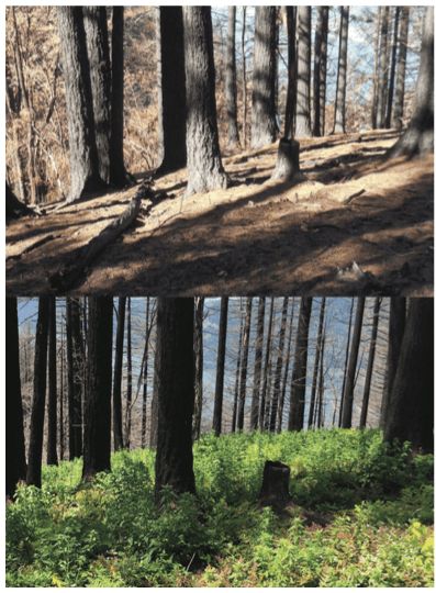
Top: Herman Creek; photo by Terry Hill · Bottom: Herman Creek, 16 months after fire; photo by Ralph Bloemers
As you pass the trailhead of the Pacific Crest Trail on the western edge of Cascade Locks, Oregon—the terminus point of Cheryl Strayed’s hike in Wild—the path curves upwards. It curves away from the river, away from the highway, and into a stand of second-growth Douglas fir trees. I’m on a guided hike with Roberta Cobb, the caretaker of a stretch of the PCT that extends about six-and-a-half kilometres from the Bridge of the Gods to the next trail junction at the Herman Bridge Trail. As we hike, Cobb and I pass trees ringed with charred bark; when we look up towards the canopy, we can see if the tree is dead or living. From many points along trails in this area, you can see down to the wide, fast-moving Columbia River, home to several different species of salmon. Members of the Yakama, Nez Perce, Warm Springs, and Confederated Tribes of the Umatilla hold treaty rights for subsistence and commercial fishing on this river and its tributaries and, if you look closely, you can spot the platforms where fishers use hoop nets to catch coho, chinook, steelhead. Cobb uses her hiking stick to point out native plants, some of which she’s seeing on this trail for the first time since she began to hike it over 30 years ago: calypso orchids, Oregon grape, trillium, vanilla leaf, Oregon anemones. The moss, which used to be up to 10 or 12 inches deep—“there are parts of this trail that felt like hobbit land,” Cobb says—just began to re-emerge this year and has only managed to develop, so far, a thin cover.
Cobb and I are hiking a post-fire forest. I was invited here by Travel Oregon. It was the first travel-writing invite I’ve ever accepted—most conventional travel writing doesn’t appeal to me much but I have an abundance of curiosity about how communities rebuild after fire. Two years ago, on Labour Day weekend 2017, a teen lobbed fireworks into the Columbia River Gorge in Eagle Creek, just west of us on an extremely popular hiking trail, igniting a blaze that tore through the underbrush. The fire burned up the top of the ridge and then burning debris fell down, inciting further burning at the top, says Jessica Bennett, Cascade Locks’ Fire Chief. The fire hopped from ridge line to ridge. It lasted over 12 weeks and became, in a year that also saw the horrific destruction of the Thomas and Detwiler Fires in California, the top priority fire in the nation for three weeks. Bennett was on a wilderness rescue across the river when she received the first call, just after 4 p.m. on the second day of September. A little later, as Bennett came around the east side of Beacon Rock, on the Washington side of the river, she was able to get a clear view down the gorge. What she saw was unsettling: a huge plume of smoke swirling upwards from Eagle Creek. Bennett’s fire crew— fire fighter and paramedic Rebecca Gehrman and a couple volunteers—had already been dispatched on-scene with a bladder bag of water and some tools. But the flames were already taking up roughly an acre of land. They’d jumped the trail, and were moving quickly up steep terrain composed of loose shale and dry grasses.
“We knew we weren’t going to fight the fire,” Gehrman says. Their objective, instead, was to get to any hikers trapped on the trail and help them and a way to safety. Gehrman and her crew couldn’t get to the hikers, but thankfully, the Forest Service did: they found about 140 people on the Eagle Creek Trail and had them hike out over 22 kilometres in the opposite direction, away from the fire, towards an area called Wahtum Lake. Many of these hikers, expecting a short jaunt into the woods to take in the scenery and take some photos, were wearing flip-flops, swimsuits, T-shirts, and shorts, not necessarily carrying water
or food. They weren’t prepared to start walking the equivalent of a half-marathon and they weren’t prepared to shelter overnight at the bottom of the canyon, the river further cooling the chilly early fall air. As the forest service guided the hikers out, the fire grew: the affected area was estimated at 300 acres by 11 p.m., and then—surprising Bennett and other fire experts, because fire isn’t generally as active at nighttime—it ballooned to 3000 acres overnight.
Late last April, I moved back to Vancouver after spending three years in Montreal; my partner, Will, our toddler and I lived in Surrey and I commuted into East Van by suburban bus and SkyTrain. As the summer stretched on, the air filled with wildfire smoke. Most days, as the SkyTrain passed over the Fraser River, the sun was a glowing pink orb in a hazy rose-gold sky. Everyone Instagrammed it. I Instagrammed it. Over three thousand people were evacuated from their homes and the fires set a new record for area burned, which had been set just a year earlier—over 13,000 square kilometres to 2017’s 12,161. It was only a couple years after fires tore through Fort McMurray, in Alberta. South of us, the Carr Fire was burning, to be followed soon after by the horriffic Camp and Woolsey Fires, which together consumed great swathes of California, tragically killing 96 people. Like it had been with Fort Mac, the footage of people escaping the areas was terrifying: cars slowed to a crawl on highways flanked with flames. It was impossible not to think about fire, to feel lucky every day that we were safe, other than for the smoke. As I write this, we’re heading back into fire season: it’s early May, and there are already fires of note burning on the Nechako Plateau, just west of Prince George, and just outside Fort St. John, on the north-eastern edge of the province.
Where I live now—Powell River, B.C., about five hours northwest of Vancouver on the northern Sunshine Coast—was logged extensively in the late nineteenth and early twentieth centuries, with old-growth logging hitting its heyday in the mid-1920s. This logging, plus a general policy to put out forest fires, has resulted in a forest that Eric Whitehead, who forages mushrooms and other wild foods for his company, Untamed Feast, now describes as “relatively boring.” “You have your second-growth Douglas fir trees and salal,” he says. “Salal, ferns, and second-growth Douglas fir.” Whitehead likens this to a “monocrop.” “We know about farming, how when you get a huge monocrop of something, if disease comes in it wipes everything down,” he says. While allowing pocket burns would have created multifaceted forests in B.C.—different kinds of trees of all different ages—the policy of avoiding as much fire as possible, in addition to the impacts of climate change, instead left the forests vulnerable to the mountain pine beetle, which has decimated trees across the province and left us even more susceptible to serious fires.
In Cascade Locks, 68-year-old Mayor Tom Cramblett—who also pilots river cruises down the river on a 147-foot sternwheeler—remembers that the tree composition of the gorge looked very different in places when he was young. The Yacolt Burn had blazed through in 1902, taking out Douglas fir and leaving, for a time, a blend of new plants and trees in its wake. Cramblett remembers, in particular, huckleberry fields up near Wahtum Lake, and bear grass fields on the Benson Plateau—people made the huckleberries into jam and pies, and made baskets out of the bear grass. “Douglas fir wipes out everything,” he says. “We protected the trees, and the noble fir moved in there and the huckleberry fields are all gone.”
In other words, the way we think about fire and interact with fire—like the way we think about and interact with many aspects of the environment that sustains us—may need to change. In B.C., logging remains an important economic driver; Whitehead underscores that in the area I live in, the forest is becoming less of a forest and more of a tree farm, one we might find ourselves needing to fertilize if we don’t begin to let more dead wood replenish the soil. In wilder areas, he says, we’d do well to let more fires burn, and to opt for controlled burns— wildfires set intentionally in order to manage the forest and help avoid out-of-control, unmanageable forest fires. The B.C. government earmarked $10 million of its wildfire budget this year for prescribed burns, and including one in Keremeos, in the fire-plagued interior, targeting 192 hectares.
Everyone I spoke to in Cascade Locks remembers where they were when they first learned of the fire. Caroline Lipp, co-owner of the Thunder Island Brewing Company, found out the severity of the fire when a customer tagged them in a photo from the brewery’s patio: looking southwest, the customer captured smoke billowing into the sky. Kim Brigham-Campbell, a fisher and a member of the Confederated Tribes of the Umatilla, could see it from the window of her fish shop. Ralph Bloemers, an attorney who works with conservation groups, was driving back to Portland on highway 84 just a few minutes before the highway was closed. He saw the fire moving fast—wind-driven embers, huge chunks of debris floating down to the highway, helicopters up in the sky looking puny in comparison to the fire. Shelley James, who owns Cascade Locks Ale House and is a volunteer trail angel, accepting mailed-ahead supplies from hikers, could see it from the Ale House’s backyard. Residents and business owners of Cascade Locks were lucky—no one died or was seriously injured, and fire fighters managed to divert the fire away from the town three times, preventing it from burning. But it was still traumatic, and many townspeople are still healing. “I was really worried that the whole town was going to be gone,” says James. “You can still smell smoke in my truck on a hot day when you lift the windows up. My sleeping bags will always smell.”
For some people, like the Mayor, considering the ways in which fire is a natural part of the cycle of the forest helps to ease the anxiety surrounding it. Bloemers and Roberta Cobb, the PCT caretaker, both participated in community forums on forest ecology and trail maintenance last fall and over the winter. Bloemers organized a trip into the charcoal forest with the local elementary school, to see nature moving forward as a metaphor for their own healing. “We started by asking them to share their own stories of the fire,” Bloemers says. “And then we took them out onto the ground.” In small groups, the students did a treasure hunt to find things like woodpecker holes—the black-backed woodpecker thrives in post-burn forest—and trees that had been burned, but were still alive. Bloemers also filmed work parties on trails that were impacted by the fire; he’d clip a GoPro to a tree or leave one on the ground as he helped to move rocks. On the Angel’s Rest Trail, he reflected on the fact that the trail, which is popular for its views, has those views because of a fire that burned in the early nineties. Bloemers says his goal is to show the benefits of fire—to deliver a message that is both hopeful and shares the hard truths.
Back in B.C., Eric Whitehead is studying last year’s burn maps to decide where he’ll pick morel mushrooms this year. Morels are a symbiotic mushroom and their fungus grows underground, like a little net that connects to the rootlet hairs of trees and shrubs. But the fungus produces fruit as a stress reaction, when its host trees are dead or dying—like after a fire, or logging. Whitehead, who grew up on a farm, and picking wild mushrooms, says that it took a few years for the beauty of the post-fire forest to kick in for him. After that, he says, “you’re walking through and you find yourself photographing little things that are just so excited for the raw opportunity to just kind of colonize the space. And then in time you started to really get it—oh yeah, this is part of the program. This isn’t a disaster here. This is part of the cycle.”
Mitch Hicks, the Chief of Enforcement for the Fisheries Enforcement Department of the Columbia River Inter-Tribal Fish Commission, stresses tempering any optimism associated with the Eagle Creek Fire—it was, after all, a human-caused fire that endangered lives and livelihoods. Tribal fishers from the Yakama, Nez Perce, Warm Springs, and Confederated Tribes of the Umatilla were in their high season—several different species of salmon run overlapping—when the fire hit on Labour Day weekend. “There’s positive effects from fire, absolutely, there are benefits,” he says. “But not in this way… There are prescribed ways to have healthy forests that are not harmful to people and don’t victimize people, and don’t victimize the environment, because the environment can be victimized as well.”
On my last full day in Oregon, my family and I hiked along the Herman Creek Trail to the Herman Bridge Trail, which Roberta Cobb had recommended when we were out on the PCT. Will pointed out a slope studded with “volcanic bombs”— lava that had been hurled from a local volcano and cooled into rocks during its descent through the air. Earlier, on the patio at the brewery, I’d marvelled at the stunning exposed cliff faces of Table Mountain: hundreds of years ago, Mayor Cramblett had explained, a massive landslide had cleaved off the mountain, partially damming the river. If I take a long-term view, it’s possible to read the landscape and see evidence of disasters past all around us—both to appreciate the resilience of the forests, rivers, and rocks, and to reorient my anxieties about climate-change-related disasters so that I am focussing less on how they may impact me, and more on the duty of care I owe to mitigate their causes and effects.